How do I activate and use the AIS+ function in the app?
What is AIS?
AIS (Automatic Identification System) is a tracking system used for collision avoidance and maritime traffic monitoring. Ships transmit their unique identification, position and travel information several times a minute using on-board AIS transponders. This AIS information can be captured by nearby ships, satellites, and by AIS stations on shore.
This is a huge benefit for safety on the water. For example, ships with AIS can “look around the bend” to see if there is oncoming traffic. This is useful at busy junctions or in other special situations on the water.
Why do we call it AIS+?
The Waterkaarten app has the ability to display AIS data from other vessels while also displaying your current position to other app users. We call this function AIS+ because, in addition to the standard AIS image, you will also see other app users. Please note that showing other app users is only visible in our app. No AIS signal is transmitted from our app, only received.
How can I use the AIS+ service?
The AIS+ service is only available to subscribed users, not the free trial version. You do not need any external hardware to receive AIS+. A stable internet connection on the device on which the Waterkaarten app (from 2022) is installed is sufficient to receive the AIS+ image.
How do I enable and disable AIS?
If you click on the AIS+ icon in the top right corner of the map, it will connect to our server and turn blue.
The AIS+ icon can have three colours:
- White: AIS+ is disabled and you are not visible to other app users
- Blue: AIS+ is enabled and you are visible to other app users
- Orange: The AIS+ signal is not as strong and the data may be less accurate
Within a few seconds you will see icons of ships equipped with AIS appear on your map. If you click on these icons, AIS data will be displayed (name, AIS number, speed, boat size and boat type).
Am I always visible too?
As long as the AIS function is activated (icon is blue or orange), you will also be visible to other users of the Waterkaarten app. It is not possible to use AIS+ yourself, but not to be visible to others.
You are only visible via AIS+ if you are located on, or very close to, the fairway. This is to prevent you from being visible as a ship on the map to other users of Waterkaarten while you have our app open at home.
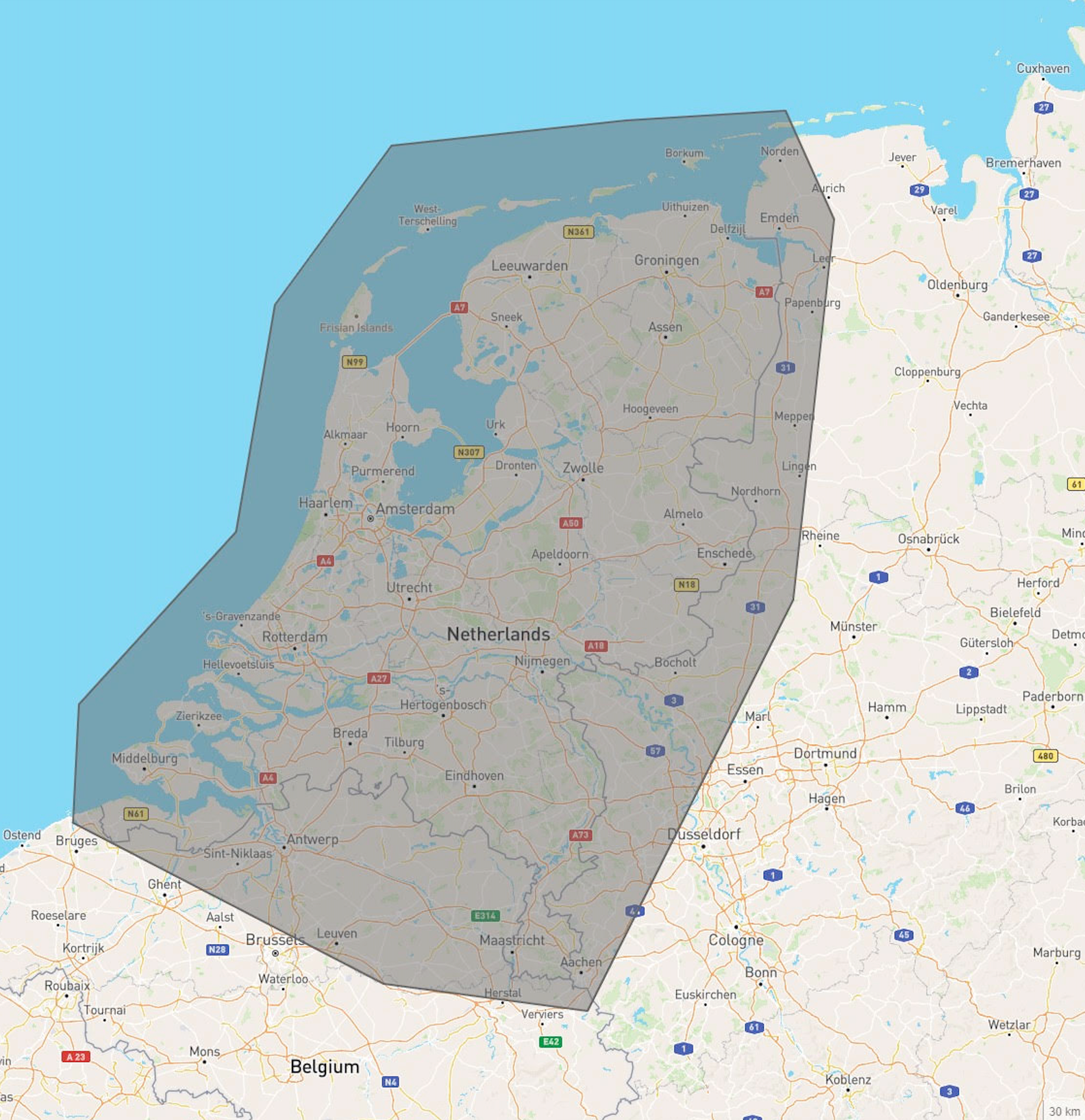
Only in the Netherlands
Currently, the AIS+ function is only available for Dutch waters and the Port of Antwerp. We are working on further expanding the functionality, but it is not yet clear when we will launch this. The image below shows the AIS+ coverage area we apply in our app. You may still have coverage outside this area, but this is not guaranteed.